
Page 135 - Changing Living Spaces
P. 135
Utilization of Grass and Wood in Common-Use Imperial Land
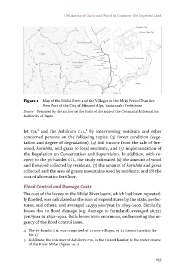
Figure 1 Map of the Midai River and the Villages in the Meiji Period That Are
Now Part of the City of Minami-Alps, Yamanashi Prefecture
Source Prepared by the author on the basis of the map of the Geospatial Information
Authority of Japan
let CIL4 and the Ashikura CIL,5 by interviewing residents and other
concerned persons on the following topics: (3) forest condition (vege-
tation and degree of degradation), (4) BIe income from the sale of fire-
wood, karishiki, and grass to local residents, and (5) implementation of
the Regulation on Conservation and Supervision. In addition, with re-
spect to the 36-hamlet CIL, the study estimated (6) the amount of wood
and firewood collected by residents, (7) the amount of karishiki and grass
collected and the area of grassy mountains used by residents, and (8) the
cost of alternative fertiliser.
Flood Control and Damage Costs
The cost of the levees in the Midai River basin, which had been repeated-
ly flooded, was calculated as the sum of expenditures by the state, prefec-
tures, and others, and averaged 14,353 yen/year in 1893–1902. Similarly,
losses due to flood damage (e.g. damage to farmland) averaged 26,221
yen/year in 1892–1901. Both losses were enormous, underscoring the ur-
gency of the flood control issue.
4 The 36-hamlet CIL was comprised of 13 new villages, or 33 former hamlets (ta-
ble 1).
5 Ashikura, the sole user of Ashikura CIL, is the closest hamlet to the water source
of the River Midai (figure 10.1).
133