
Page 236 - Changing Living Spaces
P. 236
Satoshi Murayama, Hiroko Nakamura, Noboru Higashi and Toru Terao
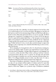
Table 2 Occurrence of Dry Days and Rainmaking Rituals from June to August
(Solar Calendar) for a Good Harvest Year, 1798, and a Drought Year, 1799
Solar C. 1798 1799
Dry days rMr events Dry days rMr events
June 13 21
July 25 21 1.Jul
4.Jul
8-12-Jul
30.Jul 21-?-Jul
August 22 2-6-Aug 26
10-12-Aug 17.Aug
Source Original digitised database from Amakusa-cho Kyoiku-iinkai (1985–1998);
UkM, Ueda Yoshiuzu Diaries.
29 (June 18 in the solar calendar), the diaries reported that on May 1 the
river swelled and seemed to overflow its banks, damaging several parts of
the banks as well. In the early morning of May 10 of the lunar calendar, a
flood occurred. The water percolated from 2:00 pm to 3:00 pm. The flood
damage was immediately investigated and a summary of the damage was
listed in a special document dated May 11. The damage is summarized in
table 3 and compared to other flood events. Residents of the cooperative
village quickly and expeditiously surveyed the damaged sites and build-
ings. Unlike the flood of 1801, it took only a week for people to report the
damage. A new image map was created in the following months to visu-
alize the disaster.
Before mapping the damaged sites after the 1803 flood, an emergency
construction project began on May 13 to stop the flow of water and pre-
vent the spread of damage. A village official inspected each damaged site
or structure, and by the end of May, broken walkways had been restored.
Local government officials came to survey the damage and estimated
that the damage in kokudaka was 130 koku, meaning that more than one-
fifth of the village kokudaka, about 615 koku, was destroyed. On July 2,
Takahama suffered further heavy damage from a large wave.
The shoya of Takahama submitted a request to the local government
on July 5 for an estimate of the number of workers needed to repair the
flood-damaged irrigation systems, including shore protection at the
mouth of the river.8 Figure 9 is a pictorial map of Takahama submitted
8 According to a description dated on July 5 in Original digitised database from
Amakusa-cho Kyoiku-iinkai (1985–1998); UkM, Ueda Yoshiuzu Diaries.
234