
Page 237 - Changing Living Spaces
P. 237
Agricultural Crises Due to Flood, Drought, and Lack of Sunshine
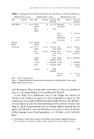
Table 3 Damage Due to Floods in 1801 (Kansei 13), 1803 (Kyowa 3), and 1817 (Bunka 14)
Floods in Jun 13, 1801 Floods in May 11, 1803 Floods in Jun 6, 1817
Type Number Scale Type Number Scale and Type Number Scale and
Remarks Remarks
River Banks 8 234 m River 38 1411.2 m River and 41 1148.4 m
Banks Tide Banks
Tide 2 63 m
Banks
River 14 8,424 m
Shelves
Mizu-Hane 4 81 m
River Weirs 14 1,568 m
Shirasu 360 m Shirasu 2 270 m
Banks Banks
Rice Fields 99 a* Rice 1,118.0 a became Rice 346.5 a became
Fields river Fields river
Rice 1,287.0 a flooded Rice 693,0 a flooded
Fields with Fields with water
water
Other sweet Other 198.0 a land slide
Fields potatoes Fields
Houses 2 collapsed Houses 4 collapsed
Huts 1 collapsed Huts 3 washed
away
Houses 8 walls
collapsed
Fishing 16 washed
Boats away
Note *a=100 square meter
Source Original digitised database from Amakusa-cho Kyoiku-iinkai (1985–1998);
UkM, Ueda Yoshiuzu Diaries.
with the request. Shortly before this submission, on July 2, an additional
297.5 a (= 100 square meter) of rice paddies were flooded.
A new draft of an illustrated map of the village was started by
Denkuro and Godayu on August 20 and completed on August 23. The
composition and content differed fundamentally between this illustrat-
ed map (figure 9) and the illustrated map drawn several months later
(map 3). The local government and the village official checked the site
again, and Takeshiro, who was invited as a new painter, drew the details
of the damaged areas from September 10 to October 9 with Sahichi’s
help.9
9 According to a description dated on October 9 in Original digitised database
from Amakusa-cho Kyoiku-iinkai (1985–1998); UkM, Ueda Yoshiuzu Diaries.
235