
Page 269 - Changing Living Spaces
P. 269
The Neverlake: Water and Land Management in a Dry and Soilless Place
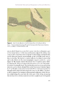
Figure 6 Anti-Erosion Barrier in the Northwest Part of the Jezero doline
Source Processed details by Gregor Kovačič of the map in the Franciscean Cadastre;
ASts, CF, Mappe, S. Daniele (Štanjel), 427b.
ure 4), which flowed in a controlled manner into the northwestern part
of the doline bottom. At the very northwestern edge of the doline, they
constructed a transverse erosion barrier to retain larger sediments that
would otherwise deposit uncontrollably on the cultivable lands and re-
duce its fertility. The barrier is clearly visible in the shaded LiDAr relief
and is also shown on the main topographic map at a scale of 1 : 5,000
(figure 8). The barrier reduced the erosive force of surface water, there-
by reducing the effects of water-induced erosion of the soil that proper-
ty owners occasionally faced. This barrier also acted as a more permanent
reservoir, as it is clearly coloured blue in the Franciscean Cadastre (figure
6). An artificially constructed channel led off from the transverse barrier
through which water drained toward the centre of the doline. The barri-
er did not impede the transport of fine-grained sediments, which the wa-
ter washed along the canal into the lower part of the doline, increasing
the fertility of the soil; the canal also served to supply water for irrigation
267