
Page 273 - Changing Living Spaces
P. 273
The Neverlake: Water and Land Management in a Dry and Soilless Place
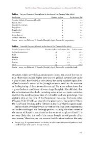
Table 1 Largest Owners of Arable Land in the Area of the Drained Lake (1822)
Landowner Number of plots Surface area (ha)
Coronini Michele (Dominion of Štanjel) 5 1.1
Beneul Jožef 1 0.9
Brusatti Gio. Battista 4 0.8
Švagelj Ivan 3 0.5
Švagelj Jožef 2 0.4
Jerič Anton 1 0.3
Beber Marjeta 2 0.3
Jakomin Frančišek 1 0.3
Source ASts, CF, Elaborati, S. Daniele (Štanjel), 659/2, Protocollo proprietary.
Table 2 Intended Purpose of Lands in the Area of the Drained Lake (1822)
Intended purpose of land Number of plots Surface area (ha) Surface area %
Field with grapevines 18 4.6 60.5
Field 15 1.9 25.0
Meadow 8 0.9 11.9
Pasture 1 0.1 1.3
Coppice 1 0.1 1.3
Total 43 7.6 100.0
Source ASts, CF, Elaborati, S. Daniele (Štanjel), 659/2, Protocollo particelle fondi.
structure, which served drainage purposes (minus the area of the two ca-
nals where they incised higher into the two gullies), covered just under
0.5 ha of land. Based on this calculation, the newly acquired agricultur-
al lands covered a size of 7.6 ha (a rough estimate based on the situation
at the beginning of the nineteenth century). The above values show that
– given the karst conditions – it was a large floodplain (the old lake), that
the infrastructure they built, including water areas, was quite extensive,
and that the newly acquired area of cultivable land was quite large. This
explains why, at the time of the Franciscean Cadastre, the locals called
this area ‘Polje’ (‘Field’), as shown by the place names ‘Nad poljem’ (‘Above
the Field’) and ‘Potok na polju’ (‘Stream in the Field’) for the upper canal.
The list of plot owners provides us with information that complements
our understanding of the drainage process. Namely, the then owner of
the manor of Štanjel is mentioned as the owner of six plots of land. It is
not very likely that the lord of the manor bought or sold parcels of his
own manor;1 therefore, we can assume that the situation from the early
1 Except, e.g., if a peasant repaid tax debts, in which case they would prefer to find
another buyer and receive money instead.
271