Page 117 - Koderman, Miha, and Vuk Tvrtko Opačić. Eds. 2020. Challenges of tourism development in protected areas of Croatia and Slovenia. Koper, Zagreb: University of Primorska Press, Croatian Geographical Society
P. 117
the importance of protected areas on the slovenian coast for tourism ...
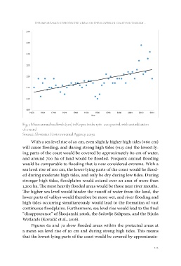
Year
Fig. 5 Mean annual sea levels (cm) in Koper in the 1961–2015 period, with an indication
of a trend
Source: Slovenian Environmental Agency, 2019a
With a sea level rise of 50 cm, even slightly higher high tides (+60 cm)
will cause flooding, and during strong high tides (+115 cm) the lowest-ly-
ing parts of the coast would be covered by approximately 80 cm of water,
and around 700 ha of land would be flooded. Frequent annual flooding
would be comparable to flooding that is now considered extreme. With a
sea level rise of 100 cm, the lower-lying parts of the coast would be flood-
ed during moderate high tides, and only be dry during low tides. During
stronger high tides, floodplains would extend over an area of more than
1,200 ha. The most heavily flooded areas would be those near river mouths.
The higher sea level would hinder the runoff of water from the land, the
lower parts of valleys would therefore be more wet, and river flooding and
high tides occurring simultaneously would lead to the formation of vast
continuous floodplains. Furthermore, sea level rise would lead to the final
“disappearance” of Škocjanski zatok, the Sečovlje Saltpans, and the Stjuža
Wetlands (Kovačič et al., 2016).
Figures 6a and 7a show flooded areas within the protected areas at
a mean sea level rise of 50 cm and during strong high tides. This means
that the lowest-lying parts of the coast would be covered by approximate-
115