Page 118 - Koderman, Miha, and Vuk Tvrtko Opačić. Eds. 2020. Challenges of tourism development in protected areas of Croatia and Slovenia. Koper, Zagreb: University of Primorska Press, Croatian Geographical Society
P. 118
challenges of tourism development in protected areas of croatia and slovenia
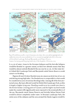
Fig. 6 Flooded areas in the event of a mean sea level rise of 50 cm and strong high tides (a),
and in the event of a mean sea level rise of 100 cm and strong high tides (b), in the areas
of Debeli Rtič Landscape Park and Škocjanski zatok Nature Reserve
Source: Surveying and Mapping Authority of the Republic of Slovenia, 2014
ly 25 cm of water. Areas in the Strunjan Saltpans and the Sečovlje Saltpans
would be flooded to a greater extent, as their low altitude means that they
would be almost entirely flooded if the sea rose by 50 cm. At this water lev-
el, Debeli Rtič Landscape Park and Škocjanski zatok Nature Reserve would
sustain no flooding.
Figures 6b and 7b show flooded areas at a mean sea level rise of 100 cm
and during strong high tides. The flooded area is comparable to what would
be considered an area of extreme flooding today. Among all of the four pro-
tected areas, the least affected would be Debeli Rtič Landscape Park, as this
is largely a higher-lying area. Flooding would occur in a small area close to
the former border crossing point of Lazaret, and the higher sea level would
make the coastal cliffs significantly more exposed to the erosional effects of
the sea. Škocjanski zatok Nature Reserve and Sečovlje Salina Nature Park
would be almost completely under water. In Strunjan Landscape Park, the
entire area of the saltpans and the area around the Stjuža Lagoon would be
116