Page 39 - Koderman, Miha, and Vuk Tvrtko Opačić. Eds. 2020. Challenges of tourism development in protected areas of Croatia and Slovenia. Koper, Zagreb: University of Primorska Press, Croatian Geographical Society
P. 39
transport accessibility as a factor of tourist flow ...
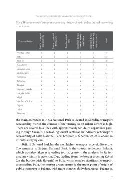
Tab. 2 The assessment of transport accessibility of national parks and nature parks according
to indicators
Protected area Public transport
connectivity
Public transport
frequency
Road connecti-
vity
Temporal distan-
ce from nearby
city/town
Temporal distan-
ce from leading
tourist centre
Total
Plitvice Lakes 1 3 3 5 5 17
Krka 1 3 4 5 4 17
Brijuni 1 3 3 4 5 16
Kopački Rit 1 3 2 5 5 16
Vransko Lake 1 3 3 4 4 15
Medvednica 1 3 2 4 4 14
Paklenica 1 3 3 3 3 13
Telašćica 1 2 3 3 3 12
Risnjak 1 1 3 4 2 11
Lastovo Islands 1 3 3 1 1 9
Lonjsko Polje 1 2 1 4 1 9
Mljet 123118
Northern Velebit 0 0 2 3 1 6
Papuk 002316
Učka 002226
Biokovo 001113
the main entrances to Krka National Park is located in Skradin, transport
accessibility within the context of the vicinity to an urban centre is high.
There are several bus lines with approximately ten daily departures pass-
ing through Skradin. The leading tourist centre as an indicator of transport
accessibility of Krka National Park, however, is Šibenik, which is about 20
minutes away by car.
Brijuni National Park has the next highest transport accessibility score.
The entrance to Brijuni National Park is the coastal settlement Fažana,
which was also taken as a leading tourist centre in the analysis. In its im-
mediate vicinity is state road D21, leading from the border crossing Kaštel
(on the border with Slovenia) to Pula, which enables significant transport
accessibility. Pula, the nearest urban centre, is the main point of origin of
public transport to Fažana, with more than ten daily departures. Fažana is,
37