
Page 200 - Changing Living Spaces
P. 200
Masanori Takashima
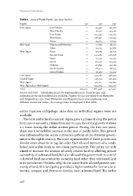
Table 2 Area of Paddy Fields, 730–1150 (in chō)
Region 730 950 1150
East Japan East Tōhoku — 51,437 45,077
West Tōhoku — 26,137 42,120
East Kantō — 103,345 101,561
West Kantō — 108,497 122,543
Tōsan — 49,769 27,692
Mid Japan Niigata and Hokuriku — 77,820 98,537
Tōkai — 50,793 59,866
West Japan Kinai — 56,249 47,612
Around Kinai — 111,289 116,818
Sanin — 31,210 32,322
Sanyō — 66,246 94,029
Shikoku — 42,899 44,186
North Kyūshū — 68,927 66,655
South Kyūshū — 38,382 32,012
East Japan — 339,184 338,994
Central Japan — 128,613 158,403
West Japan — 415,201 433,634
West Japan (incl. Mid Japan) — 543,814 592,037
Total 663,001 882,998 931,031
Sources and notes Takashima (2017). No regional data were found in 730; only
estimates at the national level are available. Figures for 950 are taken from Wamyōshō
and Shūgaishō in 1150. Since Wamyōshō and Shūgaishō have several editions with
different numerical values, the average value is employed in this table.
entire Japanese archipelago, since data on individual regions were not
available.
The total arable land in ancient Japan grew 1.3 times during the period
from 730 to 950 and 1.1 times from 950 to 1150, for a total growth of about
1.4 times during the entire ancient period. During the first 200 years,
there was a remarkable increase in the area of paddy fields. This growth
was influenced by the active cultivation policies of the Ritsuryō govern-
ment in the eighth century. The most representative of these policies was
Konden einen shizai hō in 743 (an edict that allowed farmers who estab-
lished new arable lands to own them permanently). This policy not only
aimed to increase the amount of newly created land by allowing private
ownership of cultivated land, but also allowed the government to control
cultivated land nationwide by including land other than cultivated land
in its jurisdiction (Yoshida 1983). In the sense that it allowed private own-
ership of land, this land policy provided a high incentive for farmers, aris-
tocrats, temples, and shrines to develop new cultivated land. The earlier
198