
Page 259 - Changing Living Spaces
P. 259
The Neverlake: Water and Land Management in a Dry and Soilless Place
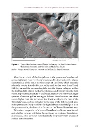
Figure 1 View of the Surface Around Štanjel Indicating the Two Dolines Jezero
(Lake) and Stočajnik, and the Raša and Lukovica Faults
Author Gregor Kovačič (map and content) and Aleksander Panjek (content).
Also characteristic of the Štanjel area is the presence of smaller and
somewhat larger, more rectilinear erosion gullies (ravines) on the slopes,
characteristic of the entire northern edge of the Karst, which descends
relatively steeply into the Branica valley and further west from Trstelj
Hill (643 m) and the surrounding hills into the Vipava valley, as well as
the northeastern edge of the Karst, which descends steeply into the Raša
valley. A special relief feature of the Štanjel area are two somewhat longer
systems of erosion gullies ending in dolines. Their bottoms are about
100 m higher than the bottom of the Branica valley in the case of the
‘Neverlake’ area, and 150 m higher in the case of the Dol Stočajnik area.
Both systems are clearly visible in the digital elevation model (figure 1). In
the present article, the discussion focuses on the ‘Jezero/Neverlake’ area.
This raises the question of when and how these landforms were formed
and whether they are still being formed today by erosional-denudation-
al processes, since corrosion is undoubtedly the predominant process of
surface transformation.
257