
Page 263 - Changing Living Spaces
P. 263
The Neverlake: Water and Land Management in a Dry and Soilless Place
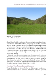
Figure 3 View of ‘Neverlake’
Author Aleksander Panjek
alluvial fan of boulders and gravel. The erosional gullies are therefore in-
herited forms of fluvial denudation, completely cut into the carbonate
bedrock. The main ponor at the bottom of the doline is a small depression
with a diameter of 4 m and a depth of 1 m (figure 2). We can only guess at
the direction of subsurface drainage from the ponor, but it is likely that
it flows underground to the northwest, to the Timavo River karst springs
on the western edge of the Karst, just as most of the infiltrated rainwa-
ter in the Karst does.
Although today the predominant process of surface transformation in
this area is corrosion, man-made structures from the past indicate pe-
riodic torrential activity. Torrents sink into sediment-covered ponors at
the bottom of the doline. The water retained in the lowest part of the do-
line on such occasions and the resulting swampiness undoubtedly gave
the doline its name – ‘Jezero’ (‘Lake’) (figure 2 and 3).
‘Neverlake’ Near Štanjel: Historical Accounts
The landlord of Štanjel, Johann Philipp von Cobenzl, who was also vize-
dom (representative of the Archduke) in Carniola, addressed a petition
261